In-Person EEMS Training Edmonds, WA · Sept 21–23, 2026 Register →
Navigation

Sedimentation

Sediment transport and deposition modeling for ports, navigation channels, and contaminated-sediment sites — with the VIMS and SEDZLJ sub-models.

Sediment Transport & Channel Sedimentation

Maintaining safe depths in ports and navigation channels is an ongoing challenge. Sediment can deposit quickly after dredging, raising costs and creating safety risks — while resuspension can spread contamination and affect water quality.

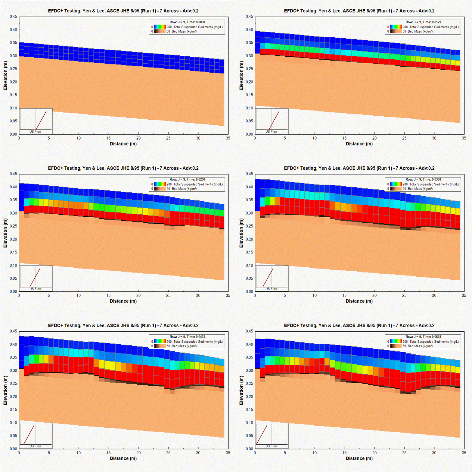
EFDC+ simulation of total suspended sediment transport in a vertical section. EFDC+ simulation of total suspended sediment transport in a vertical section.
Total suspended sediment simulation in EFDC+
EEMS Capabilities

EEMS offers two state-of-the-art sediment transport models: the VIMS-developed EFDC sub-model, and the SEDZLJ model from Sandia National Labs, which incorporates site-specific flume data for a physically consistent treatment of bedload and suspended sediment. Both are fully coupled to toxics simulation.

Projects

Port of Anchorage, Alaska, USA — Harbor Expansion Sedimentation

Visit source

The US Army Engineer Alaska District used EEMS to assess how different expansion configurations for the Port of Anchorage would affect sedimentation rates in the harbor. A series of model runs compared deposition patterns under each scenario, giving planners the information they needed to proceed with confidence.
Little Lake Butte des Morts, Wisconsin, USA — PCB and Sediment Dynamics

Visit source

DSI developed a 3D model of Little Lake Butte des Morts on the Fox River to study how sediment and PCBs move and settle in this impounded reach. The model uncovered spatial patterns in deposition and erosion that reshaped the scientific understanding of PCB dynamics in this Superfund-affected system.

Novato Watershed, California, USA — Flood Management and Dredging

Visit source

DSI built a high-resolution model of Novato Creek and its floodplain, linked to a broader domain model reaching San Pablo Bay. The modeling evaluated several flood management alternatives, including options to cut dredging frequency and costs — showing how EEMS can weigh hydraulic, sediment, and environmental factors together.

Novato Creek flood-management and sediment modeling

Berry's Creek, New Jersey, USA — Superfund Sediment Transport

Visit source

At the Berry’s Creek Superfund site in the Hackensack River Meadowlands, DSI validated EFDC+ against existing models and field data, then applied Lagrangian particle tracking to trace PCB-, mercury-, and metal-bound sediments back to their sources. The work supported expert litigation on how cleanup costs should be allocated.

Cook Inlet, Alaska, USA — Coastal Circulation and Sediment

Visit source

DSI’s EFDC+ model of Cook Inlet simulated tidal circulation, density effects, ice-covered conditions, and river inflows to support an NPDES permit review for wastewater discharge. The model informed the ecological risk assessment for the Cook Inlet beluga whale — an ESA-listed species that depends on the health of this inlet. Free grid →

Huong River Basin, Vietnam — Flash Flood and Channel Dynamics

Visit source

EEMS was applied to the Huong River Basin as part of a flash flood warning system for Hue City, which regularly experiences severe flooding from monsoon rains. The hydrodynamic model supports real-time flood forecasting, helping emergency managers issue timely warnings and coordinate evacuations.

Puget Sound, Washington, USA — Sediment and Contaminant Transport

Visit source

EEMS has supported multiple sediment studies in Puget Sound, including propeller wash scour modeling and fish passage work at the Ballard Locks. The complex tidal dynamics and sensitive salmon habitat of Puget Sound make it a demanding environment where EEMS’s full modeling capabilities are put to good use.

Puget Sound propeller wash and sediment simulation
Puget Sound sediment and contaminant transport
Dam with mountains