In-Person EEMS Training Edmonds, WA · Sept 21–23, 2026 Register →
Navigation

Dredging Impacts

Dredging impact and dredge-plume assessment with open-source EFDC+ — sediment transport fully coupled to toxics.

Assessing Dredging Impacts

Dredging keeps ports and channels open, but it can stir up contaminated sediments, alter circulation, and affect sensitive marine habitats. Assessing and managing these impacts requires flexible, open-source tools that work across a range of regulatory settings.

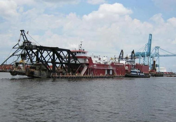
Dredging project on the Lower St. Johns River. Dredging project on the Lower St. Johns River.
Dredging on the Lower St. Johns River
EEMS Capabilities

EEMS is widely used for dredging impact assessments. EFDC+‘s open-source status makes it accessible in cases where proprietary tools like MIKE 3 cannot be used. Both sediment models are fully coupled to toxics simulation, enabling assessment of contaminated material transport alongside standard dredge plume work.

Projects

Lower St. Johns River, Florida, USA — Jacksonville Harbor Deepening

Visit source

EFDC+ with Sigma-Zed was used to assess how deepening Jacksonville Harbor would affect salinity and navigation in the Lower St. Johns River. The partially stratified estuary requires a 3D model to accurately simulate depth-varying salinity — a point the Army Corps of Engineers’ feasibility study confirmed, making EEMS the right tool for the job. Read the external publication →
Pearl Harbor, Hawaii, USA — Dredge Plume Assessment

Visit source

DSI built a calibrated EFDC+ model of Pearl Harbor and the adjacent coast to simulate harbor circulation under trade wind and calm conditions. The model was used to predict how a dredge plume from an upcoming project would spread, and whether it would reach the coral reefs near the harbor entrance — information critical to the environmental assessment.

Dam with mountains