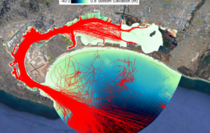
Propeller Wash Simulation Using Historical Ship Track Data
 Simulation of the impacts of propeller wash in hydrodynamic and sediment transport models requires detailed information on ship travel routes and the physical characteristics of each ship. To simulate the historical impact of propeller wash on sediments, DSI has designed EEMS to draw on data from the Automatic Identification System (AIS), which provides ship course, speed, and heading for all vessels fitted with AIS transceivers throughout the world. AIS collects data in real time using both VHF signals and satellite tracking; it is used predominantly to avoid collisions between ships. Currently, the International Maritime Organization (IMO) requires the use of AIS by all vessels larger than 300 gross tonnage that travel internationally.
 The propwash sub-model in EEMS was designed to quickly load and process the AIS data. U.S. government support agencies such as MarineCadastre.gov, and commercial operators such as Vessel Finder, Marine Traffic, and My Ship Tracking, provide this data free, with certain limitations. AIS relies on a ship’s Maritime Mobile Service Identity (MMSI) code, which can be downloaded along with time, position, course, heading, and speed for easy importing into EE. Users of EE can also configure other data sets into this column format and then load and edit the data as required. Using a number of EEMS filtering tools, ships can be selected within a specified time frame or special domain of interest. Ship tracks can also be automatically interpolated to fill missing points or split into finer segments by time and/or distance. This allows for manual editing in a 2D map view to ensure the tracks fall within the appropriate navigation channels.
 With the ship track in EE, the user can then load the physical characteristics of the ship from a number of online databases. This populates the EEMS ship database with information such as the dimensions and tonnage of each ship. If data is not available, the user may estimate and enter these values into the system manually. In this way, an accurate picture can be built up of ship movement in a port or other area of interest in a water body. The propwash sub-model will create a 2D mesh of the propeller impacts in the model subdomain, which the user can then use to visualize each ship moving through the domain and its associated impacts on the sediment bed.
Look out for more details of this exciting new development in the coming weeks.
Want to give EEMS a try with propwash? You can start by downloading EEMS and activating in the free demo mode and the running our demonstration model. To see these features in action, head over to our YouTube page. Also, learn more technical details of the implementation of this feature by reading our whitepaper on propwash.


